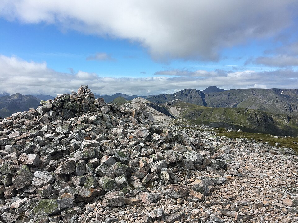
East of Ben Nevis, hidden behind the crowds and the tourist path, lies some of the highest and wildest ground in Britain. The Fort William hills do not end at the Ben: they run on eastward into the massive whalebacks of the Aonachs and the long, glittering crest of the Grey Corries. These are big, remote, committing mountains, and among the finest ridge walking anywhere in the Highlands. They are also a good deal quieter than their famous neighbour — you can spend a full day up here in high summer and meet almost no one.
The lie of the land
Think of it as one great chain. At the western end stands Ben Nevis, linked by the sweeping arc of the Càrn Mòr Dearg arête to Càrn Mòr Dearg itself. East of that rise the two Aonachs — Aonach Mòr and Aonach Beag — enormous, flat-topped mountains that are the seventh and eighth highest in the country. Beyond them, across the remote bealach at the head of the Lairig Leacach, begins the Grey Corries proper: Sgùrr Choinnich Mòr, then the long pale ridge over Stob Coire an Laoigh and Stob Choire Claurigh, with Stob Bàn hanging off to the south.
The Grey Corries ridge
The Grey Corries take their name from the pale grey quartzite that caps the whole ridge. On a bright day the crest genuinely shines, and the walking along it is a joy: a narrow, rocky, switchbacking arête that stays high for miles, with steep drops into corries on either side. The classic traverse runs the length of the ridge, taking in Stob Choire Claurigh — the highest of the group at 1,177m — Stob Coire an Laoigh and Sgùrr Choinnich Mòr, with the detour south to Stob Bàn if you have the legs. It is one of the great ridge walks in Scotland, and it feels a world away from the roadside Munros of the south.
Underfoot the quartzite makes for slow, careful going in places — blocky and awkward rather than technical, but tiring over a long day, and slippery when wet. The reward is the position: for hour after hour you are perched high on a crest with Ben Nevis filling the western sky and the wilds of the Central Highlands rolling away east. Stob Bàn, set slightly off the main line, is often skipped by those in a hurry, but it is a fine little peak in its own right and worth the extra pull if the weather is kind and the legs are willing.
The Aonachs: bulk and steepness
The Aonachs are a different animal. Where the Grey Corries are all about the crest, the Aonachs are about sheer mass — vast, grassy, plateau-like summits that hide dramatic eastern crags falling into remote corries. Aonach Beag is the higher of the two at 1,234m; Aonach Mòr, its northern neighbour, carries the Nevis Range ski area on its flank. Navigation on the broad tops demands care: in cloud, these featureless plateaux are exactly the kind of ground where people walk off the wrong edge, and the eastern faces are steep enough to be lethal. Bring the navigation skills to match the terrain.
Getting in: Corriechoille and the gondola
Access shapes everything here. The traditional way in is from Corriechoille, the small road-end southeast of Spean Bridge, from which a track leads up into the Lairig Leacach and gives the natural approach to both the Grey Corries and the eastern side of the Aonachs. It is a long walk in — several miles before you even start climbing — which is a large part of why these hills stay quiet.
The other option is more unusual. The Nevis Range gondola above Torlundy carries you most of the way up Aonach Mòr's northern shoulder, turning what would be a huge day into a much shorter one. Bagging Aonach Mòr and Aonach Beag from the top of the gondola is a genuinely useful shortcut — though check the running times, since the last downhill car is not late, and being stranded up high is no fun. If you would rather earn every metre, both hills can be climbed on foot from Glen Nevis to the south, but that is a much longer and rougher outing.
For those wanting to link the range into a bigger expedition, the Lairig Leacach itself is the key. A small unlocked bothy sits in the glen, giving shelter for a night and turning the whole area into a two-day proposition: in over the Grey Corries on day one, a night in the glen or under canvas, and out over the Aonachs and beyond on day two. It is one of the more rewarding ways to see this country, and it takes the time pressure out of a very big round.
The big traverses
Fit and experienced parties link these hills into some of the most satisfying long days in the Highlands. A full traverse of the Grey Corries from Corriechoille is a big outing in itself. Stronger walkers extend it westward over Sgùrr Choinnich Mòr and up onto the Aonachs, and the very committed carry on to Càrn Mòr Dearg and even Ben Nevis, crossing every one of these summits in a single enormous horseshoe. That last combination is one of the classic expeditions of Scottish hillwalking, and most people quite sensibly split it across two days, or throw a tent or a bothy into the plan.
Take the remoteness seriously
These are not hills to underestimate. The distances are long, the escape routes few, and the ground genuinely mountainous — steep, rocky and exposed in places, with real consequences if the weather turns. Phone signal is patchy at best, and once you are committed to the ridge, bailing out means either retracing your steps or a long, pathless descent into a remote glen. Carry enough food and warm kit for a day that overruns, tell someone your plan, and set a firm turnaround time so a slow start does not leave you finishing in the dark.
In winter they become full mountaineering propositions, corniced and icy, and should only be attempted with the skills and kit that a winter round demands — an ice axe, crampons and the experience to use both. The narrow quartzite crest of the Grey Corries and the corniced edges of the Aonach plateaux are unforgiving under snow. Even in summer, treat a day here with the same respect you would give Ben Nevis next door; the fact that these hills are quieter does not make them any kinder.
Planning your round
Because the approaches are so long and the linking options so varied, these hills reward careful planning more than most. Work out in advance which summits you realistically want, where you will start and finish, and how you will get down if the cloud comes in. Store the routes and offline maps for the whole chain in the Munros app before you set off, so you can follow your progress along the ridge and tick each of these hard-won summits as you cross it — signal or no signal.
Related guides
- How to climb Ben Nevis — the neighbour at the end of the chain
- Best Munro ridge walks — where the Grey Corries belong
- Best multi-day Munro routes — for linking the whole horseshoe
Munros in this article
Browse Related Hubs
Track your Munros
Log summits, get summit weather, and follow GPS routes for all 282 Munros. Free on the App Store.
Download the Free App